
Japan earthquake and tsunami of 2011
Our editors will review what you’ve submitted and determine whether to revise the article.
- National Geographic - Tohoku Earthquake and Tsunami
- NOAA National Center for Environmental Information - Japan Earthquake and Tsunami
- National Center for Biotechnology Information - PubMed Central - Characteristics of the 2011 Tohoku Tsunami and introduction of two level tsunamis for tsunami disaster mitigation
- LiveScience - Japan Earthquake and Tsunami of 2011: Facts and Information
- Date:
- March 11, 2011
- Context:
- earthquake tsunami Fukushima accident
Recent News
What was the magnitude of the earthquake that caused the tsunami that devastated coastal areas of Japan in 2011?
Where was the epicenter of the Great Sendai Earthquake?
What was the death toll of the earthquake and tsunami that struck Japan in 2011?
What effects did the Japan earthquake and tsunami of 2011 have?
By what names is the Japan earthquake and tsunami of 2011 known?
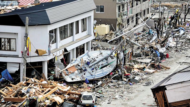
Japan earthquake and tsunami of 2011, also called Great Sendai Earthquake or Great Tōhoku Earthquake, severe natural disaster that occurred in northeastern Japan on March 11, 2011. The event began with a powerful earthquake off the northeastern coast of Honshu, Japan’s main island, which caused widespread damage on land and initiated a series of large tsunami waves that devastated many coastal areas of the country, most notably in the Tōhoku region (northeastern Honshu). The tsunami also instigated a major nuclear accident at a power station along the coast.
The earthquake and tsunami
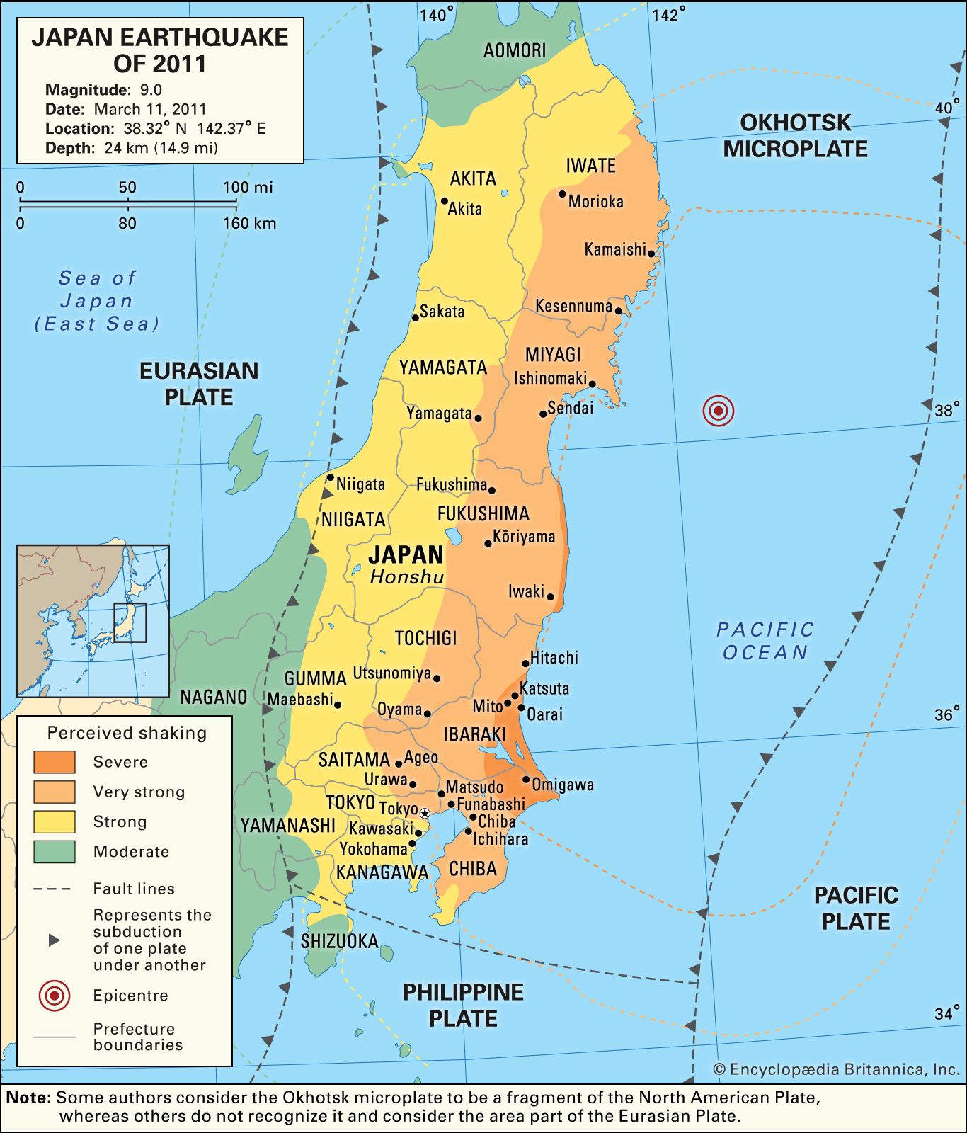
The magnitude-9.0 earthquake struck at 2:46 pm. (The early estimate of magnitude 8.9 was later revised upward.) The epicentre was located some 80 miles (130 km) east of the city of Sendai, Miyagi prefecture, and the focus occurred at a depth of 18.6 miles (about 30 km) below the floor of the western Pacific Ocean. The earthquake was caused by the rupture of a stretch of the subduction zone associated with the Japan Trench, which separates the Eurasian Plate from the subducting Pacific Plate. (Some geologists argue that this portion of the Eurasian Plate is actually a fragment of the North American Plate called the Okhotsk microplate.) A part of the subduction zone measuring approximately 190 miles (300 km) long by 95 miles (150 km) wide lurched as much as 164 feet (50 metres) to the east-southeast and thrust upward about 33 feet (10 metres). The March 11 temblor was felt as far away as Petropavlovsk-Kamchatsky, Russia; Kao-hsiung, Taiwan; and Beijing, China. It was preceded by several foreshocks, including a magnitude-7.2 event centred approximately 25 miles (40 km) away from the epicentre of the main quake. Hundreds of aftershocks, dozens of magnitude 6.0 or greater and two of magnitude 7.0 or greater, followed in the days and weeks after the main quake. (Nearly two years later, on December 7, 2012, a magnitude-7.3 tremor originated from the same plate boundary region. The quake caused no injuries and little damage.) The March 11, 2011, earthquake was the strongest to strike the region since the beginning of record keeping in the late 19th century, and it is considered one of the most powerful earthquakes ever recorded. It was later reported that a satellite orbiting at the outer edge of Earth’s atmosphere that day had detected infrasonics (very low-frequency sound waves) from the quake.
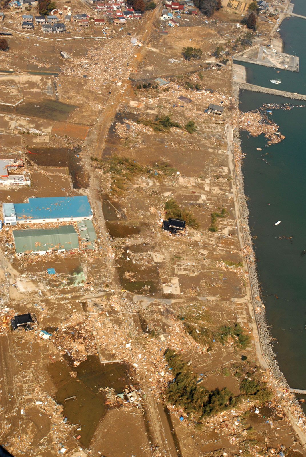
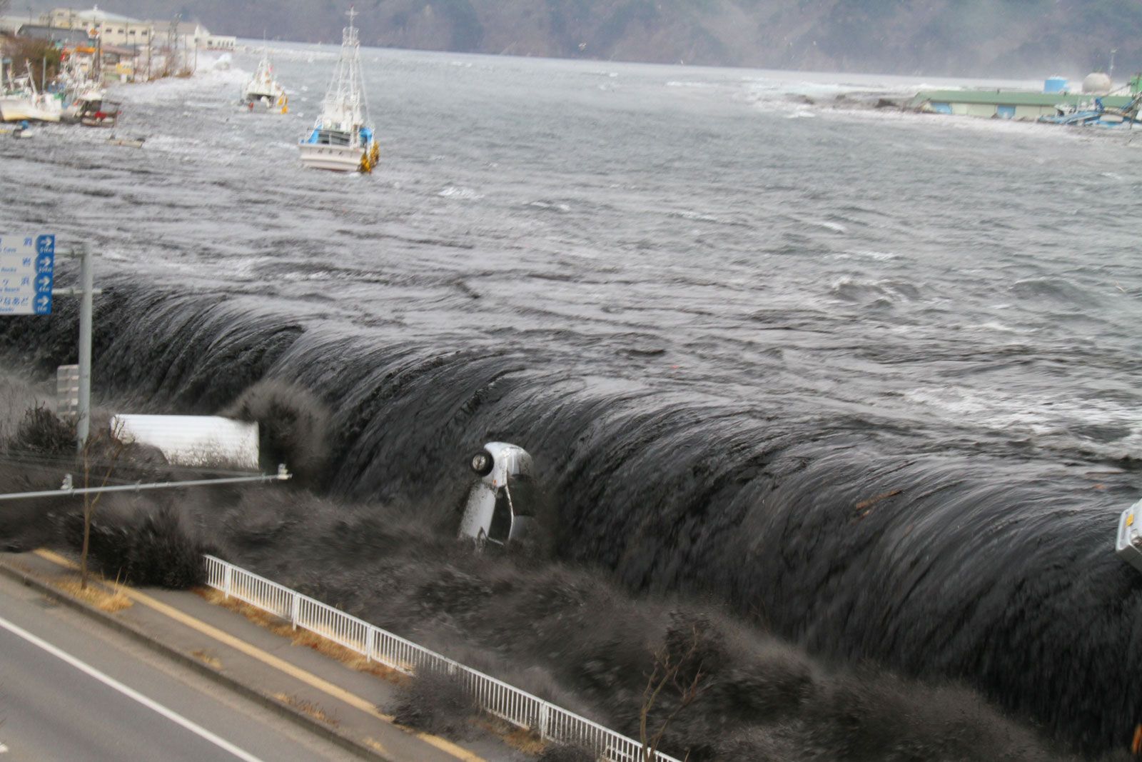
The sudden horizontal and vertical thrusting of the Pacific Plate, which has been slowly advancing under the Eurasian Plate near Japan, displaced the water above and spawned a series of highly destructive tsunami waves. A wave measuring some 33 feet high inundated the coast and flooded parts of the city of Sendai, including its airport and the surrounding countryside. According to some reports, one wave penetrated some 6 miles (10 km) inland after causing the Natori River, which separates Sendai from the city of Natori to the south, to overflow. Damaging tsunami waves struck the coasts of Iwate prefecture, just north of Miyagi prefecture, and Fukushima, Ibaraki, and Chiba, the prefectures extending along the Pacific coast south of Miyagi. In addition to Sendai, other communities hard-hit by the tsunami included Kamaishi and Miyako in Iwate; Ishinomaki, Kesennuma, and Shiogama in Miyagi; and Kitaibaraki and Hitachinaka in Ibaraki. As the floodwaters retreated back to the sea, they carried with them enormous quantities of debris, as well as thousands of victims caught in the deluge. Large stretches of land were left submerged under seawater, particularly in lower-lying areas.
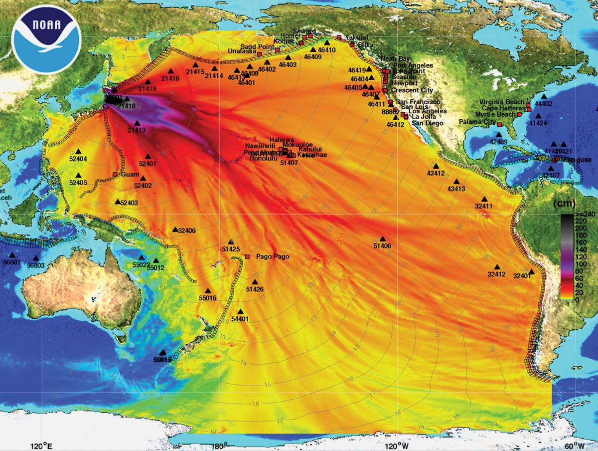
The earthquake triggered tsunami warnings throughout the Pacific basin. The tsunami raced outward from the epicentre at speeds that approached about 500 miles (800 km) per hour. It generated waves 11 to 12 feet (3.3 to 3.6 metres) high along the coasts of Kauai and Hawaii in the Hawaiian Islands chain and 5-foot (1.5-metre) waves along the island of Shemya in the Aleutian Islands chain. Several hours later 9-foot (2.7-metre) tsunami waves struck the coasts of California and Oregon in North America. Finally, some 18 hours after the quake, waves roughly 1 foot (0.3 metre) high reached the coast of Antarctica and caused a portion of the Sulzberger Ice Shelf to break off its outer edge.